
Coastal Banks
From the sunset-colored cliffs of Aquinnah to the picturesque bluffs of Siasconset, ocean-facing coastal banks are fragile environments threatened by intensifying storm events, development, and sea level rise. Among the more than 31 miles of coastal banks on Martha’s Vineyard, Gosnold (Elizabeth Islands), and Nantucket, many are anchored neither by rock nor even dense gravel. This makes them more vulnerable to erosion and also jeopardizes all that these slopes between upland areas and the sea contain — from trails, parking lots, and houses to the archaeological remains of indigenous communities and fossils of prehistory.
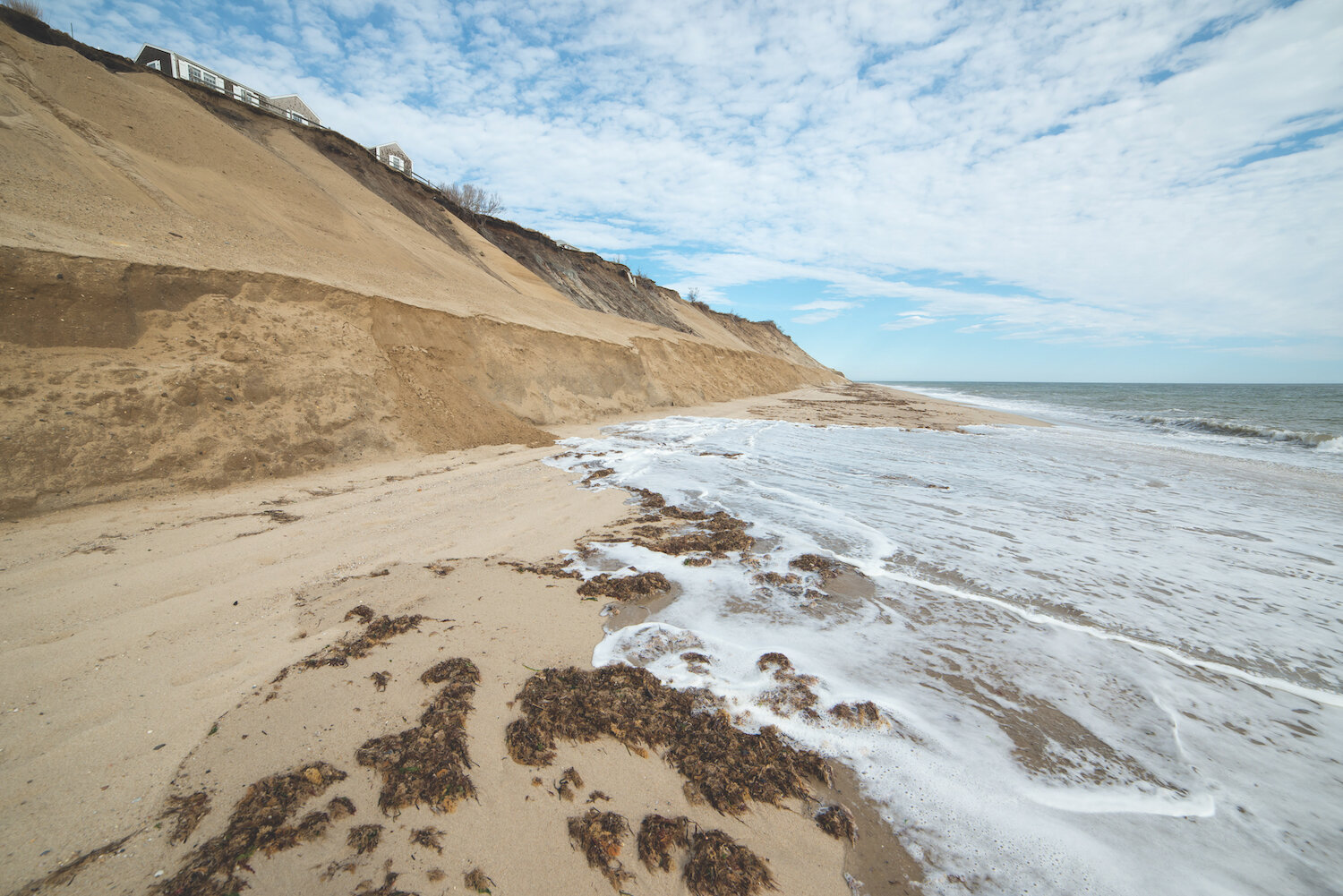
“Sconset Bluff Erosion,” photo by Greg Hinson
Coastal erosion is a natural process, but new mapping projections by FEMA indicate its pace is likely to accelerate with sea level rise as storms are able to attack higher and higher land elevations. The impacts are more highly episodic on bluffs than on beaches, causing sudden collapse and retreat. And unlike beaches, for which they are a critical source of sand, coastal banks are not self-healing. When they are gone, they are gone.
WHAT THE DATA SHOWS
According to our historical and recent data, coastal banks on the Islands are rapidly disappearing. Consider:
Gay Head Cliffs has eroded as much as 70 feet between 1990 and 2014, or almost 3 feet per year [CIT. 18].
Wasque on Chappaquiddick has receded as much as 1,500 feet since 1897 — the equivalent of nearly 5 city blocks. Data shows recent erosion rates of more than 50 feet per year [CIT. 5].
The bluffs at Siasconset have eroded over 100 feet in places between 1990 and 2014, over 4 feet per year [CIT.18]. FEMA also predicts the glacial Siasconset bluffs could erode another 300 feet or more by 2100 [CIT. 10].
Sections of coastal banks on Tuckernuck Island have eroded more than 500 feet between 1990–2014, approximately 20 feet per year [CIT. 18].
Gosnold has 11.1 miles of coastal bank [CIT. 4] (more than any town in our study), but they are generally more stable than elsewhere on the Islands.
WE’RE AT A PIVOTAL MOMENT TO SIGNAL HOW WE ARE GOING TO RESPOND TO CLIMATE-DRIVEN IMPACTS. It’s a time when we need to begin charting a future course not just for one coastal bank in a single location, but across towns and islands — and the ecosystems to which they are tied.
LOOKING AHEAD
Several places on the Islands illustrate the ways in which we might respond to the challenges facing both natural and developed coastal banks. These include:
RETREAT Development sits on top of 31% of coastal banks on the Islands, and as much as 80% on Oak Bluffs [CIT. 4]. While their homes offer elevated and often spectacular coastal views, it’s clear that owners like those above Siasconset Beach on Nantucket must start deciding what to do or where to go [see East House callout box]. We can’t expect them to act alone when resources are finite and decisions about natural resources have repercussions that transcend property lines. On an island-wide basis, we need to collaboratively consider the costs and benefits of short-term withdrawal from banks versus true retreat inland — and where that retreat, if possible, might occur. Consider:
A couple on Nantucket paid $1.6 million to move their house back from Pocomo Head bluff, while Martha’s Vineyard homeowners moved their 8,000-square-foot home after seeing 20 to 30 feet of Wasque bluff lost in a single day. “It was becoming increasingly obvious that, unless some miracle happened, we could be in serious trouble,” the homeowner told The Trustees.
In 2007, ‘Sconset Trust moved Sankaty Head Lighthouse 405 feet northwest from where it stood on the edge of a bluff, but it was a short-lived gain. It now stands about 240 feet away. In 2015, Gay Head Lighthouse stood 46 feet from the edge of Aquinnah’s clay and sand cliffs. Without moving that year, “it would tumble into the sea,” said lighthouse keeper Richard Skidmore at the time.
STABILIZATION Coastal banks are difficult to stabilize against more than minimal erosion in high energy wave environments. Hardened structures are not generally appropriate unless there is an absolute need to protect critical infrastructure. Nature-based solutions, in contrast, take into account the interconnectedness of coastal banks to what surrounds them. Consider:
At Wasque, The Trustees and our partners are preparing to trial light touch, nature-based bank stabilization to restore eroded areas. We’re also planning for retreat when the loss of parking lots and trails is likely.
Wilkinson Ecological Design stabilized a severely undercut bank by a Martha’s Vineyard home with a plant-focused, bioengineered approach. The design using native plants has served to protect the property, filter stormwater, and provide wildlife habitat.
Elsewhere, the Puget Sound National Estuary Program is studying the feasibility of a Revolving Loan Fund (RLF) to help waterfront homeowners finance the removal of damaging armor and install nature-based erosion controls. Maryland’s Shore Erosion Control RLF, one of the oldest in the nation, has been a blueprint for similar programs.